The STRR Effect: North Bangalore's Quietest Infrastructure Story
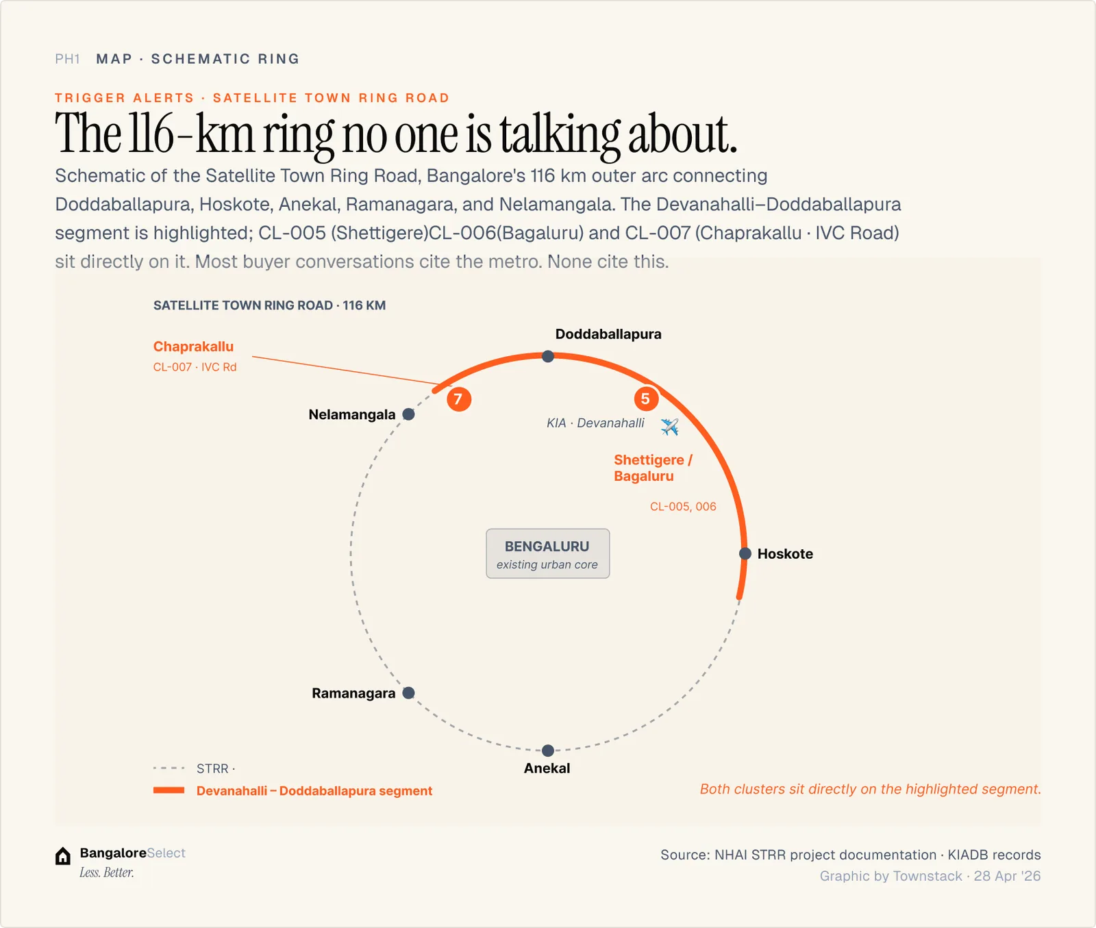
Every buyer conversation in North Bangalore reaches the metro. The Satellite Town Ring Road is the trigger nobody is talking about, and for the IVC Road and Chaprakallu corridor, it may be more relevant than the metro.

Every buyer conversation in North Bangalore eventually reaches the metro. The BMRCL Blue Line extension to the airport is the trigger most buyers understand. It is real, it is funded, and it is under construction.
The Satellite Town Ring Road is the one nobody is talking about. That asymmetry is worth examining.
What the STRR is
The Satellite Town Ring Road is a 116-km peripheral ring road designed to connect Bangalore's outer satellite towns: Doddaballapur, Devanahalli, Hoskote, Attibele, Bidadi, Magadi, and Nelamangala. When complete, it will create a continuous ring road at the city's outer edge, separate from the existing Outer Ring Road, which runs through established urban Bangalore.
The Devanahalli segment is the most relevant for North Bangalore residential buyers. Running north from Bengaluru toward Doddaballapura, passing through the Devanahalli taluk where KIA is located, this segment directly serves the IVC Road belt, Chaprakallu, and upper Shettigere.
Why it matters more than the metro for parts of the northern cluster
The IVC Road belt, including Chaprakallu, upper Shettigere, and Bagalur cross, is a low-density residential and plotted-development market. The buyer profile is different from the apartment buyer in Hebbal or Yelahanka. These are villa buyers, plot buyers, and buyers who prioritize low density and private mobility over transit access.
For this buyer, metro proximity is not the primary calculus. They drive. The infrastructure that changes their commute economics is road infrastructure, specifically, road infrastructure that reduces travel time to employment nodes without routing through central Bangalore.
The STRR, when complete on the northern arc, reduces travel time from the IVC Road belt to the Doddaballapur industrial corridor, to the KIADB Aerospace Park, and to the airport, all without entering central Bangalore traffic. That is the value proposition.
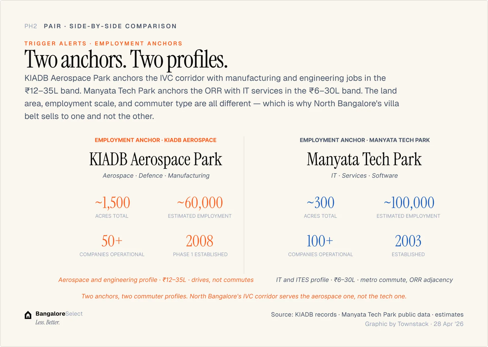
The KIADB connection
KIADB's Aerospace Park Phase 2 expansion is the employment anchor directly in this corridor's catchment. The Aerospace Park was established for the aerospace manufacturing cluster including HAL, NAL, Hindustan Aeronautics, and the defence corridor that runs from Yelahanka to Bagalur.
The resident employee base for aerospace manufacturing is an engineering and specialist manufacturing profile, senior technical staff who can afford the ₹14,500-₹18,000 psf range of Chaprakallu and IVC Road plotted development. They are not typically metro commuters. They drive to work. Better road connectivity is what changes their location calculus.
The Karnataka elevated corridors overlay
The Karnataka Cabinet approved a ₹13,262 crore package for 11 elevated corridors on April 16, 2026. The package specifically includes the Doddaballapur Road, which overlaps with the STRR northern alignment, and the STRR connector from Devanahalli to the industrial corridor.
This is not a metro story. It is a road infrastructure story: elevated corridors designed to decongest and accelerate surface movement on the same routes that the STRR will eventually serve.
The overlap between the Karnataka elevated corridors package and the STRR alignment is not coincidental. The same stretch of road, from the airport area toward Doddaballapur and the industrial corridor, is receiving infrastructure investment from two separate programmes simultaneously.
Who is already positioning for this
The active projects in the IVC Road and Chaprakallu belt are from developers who have made a deliberate call that this corridor is underpriced relative to its long-term infrastructure trajectory.
Assetz Codename Palmscape makes the same implicit argument. Its buyer is not the Manyata Tech Park commuter buying into the metro thesis. Its buyer is the aerospace professional, the GCC director with a car, the buyer who wants 40 acres of low-density development and is willing to hold a 5-7 year view on road infrastructure delivery.
The risk that is different from the metro story
Metro Phase 2B's risk is primarily timeline: the line is fully funded, under active construction, and aligned with confirmed station positions. The risk is a 12-month slip, not a fundamental delay.
STRR's risk is different. The STRR is a large infrastructure project with a complex multi-state funding structure. Its timeline is less certain than the metro. The elevated corridors package (Cabinet-approved, ₹13,262 crore) is further along the funding curve than the full STRR. Cabinet approval means the money is committed. The STRR in full is a more complex programme.
The infrastructure that is talked about least is often the one that has the most room to move price when it arrives.
Sources: Karnataka elevated corridors: Deccan Herald, April 16, 2026. KIADB Aerospace Park: KIADB official. BMRCL Phase 2B: BMRCL official communications.